Enhancing Surface PM2.5 Air Quality Estimates in GEOS Using CATS Lidar Data
May 1, 2025· ,,,·
1 min read
,,,·
1 min read
Alex Matus
Edward P. Nowottnick
John E. Yorks
Arlindo M. da Silva
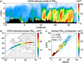 Image credit: NASA Cloud-Aerosol Transport System (CATS)
Abstract
Spaceborne lidar offers unique advantages for improving global estimates of fine particulate matter (PM2.5), traditionally limited by critical data gaps in the vertical dimension. Here, we present a new method to retrieve PM2.5 relying on ensembles of aerosol extinction available within the GEOS Aerosol Data Assimilation. This study uses 1064-nm backscatter lidar data from the NASA Cloud-Aerosol Transport System (CATS) and model priors from the GEOS model. First, we developed a 1-D ensemble-based variational technique (1-D EnsVar) to perform vertically resolved retrievals of speciated aerosol extinction and surface PM2.5. Next, we evaluated the performance of 1-D EnsVar retrievals of PM2.5 and extinction through an independent validation using measurements from spaceborne, airborne, and ground-based platforms. This approach overcomes traditional limitations by leveraging the strengths of complementary vertical aerosol information from CATS and GEOS to better resolve speciated aerosol optical properties and mass. Given the unique capability of CATS to process vertical profile data in near real-time, this work demonstrates the powerful utility of spaceborne lidar for improving air quality forecasting.
Type
Publication
Earth and Space Science
This work introduces a pioneering data-fusion strategy that bridges the gap between columnar satellite observations and ground-level exposure by incorporating vertical profiles from spaceborne lidar.
Key Methodology Updates
- 1-D EnsVar Technique: An ensemble-based variational retrieval workflow that optimizes speciated mass data from the GEOS model utilizing real-time 1064-nm lidar backscatter.
- Vertical Profiling: Overcomes traditional column-integrated limits by resolving complex aerosol layering systems that decouple standard satellite AOD signals from surface levels.
- Forecast Integration: Showcases near real-time processing capabilities critical for global air quality models and public health alerts.

Authors
Weather Analyst / ML Researcher
I am an Atmospheric Scientist and Machine Learning Researcher at NASA Goddard Space Flight Center / UMBC. My work focuses on pushing the limits of weather, climate, and environmental predictability by combining massive multi-sensor satellite observations, high-performance computing (HPC), and advanced machine learning architectures.